Torean Trekking Route: Exploring the Hidden Valley of Mount Rinjani
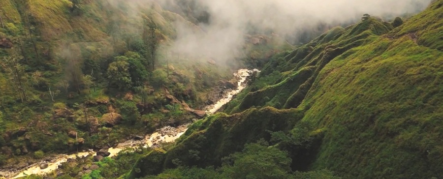
The Torean Trekking Route is an official hiking trail on Mount Rinjani. It starts in Torean Village, North Lombok. Many hikers call this trail the “Jurassic Park of Rinjani.”
The scenery here looks completely different from other routes. You will walk through a deep green valley surrounded by giant cliffs. You will also see sulfur rivers, natural hot springs, and massive waterfalls.
This trail goes straight to Segara Anak Lake without climbing high crater rims first. Because of this, most hikers use Torean as their exit route after reaching the summit via Sembalun.
Checkpoints, Elevation, and Distance
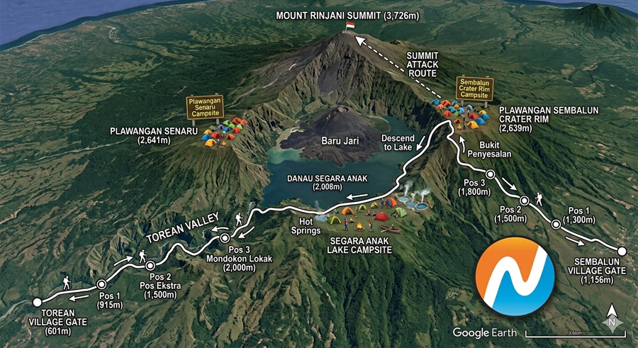
Other Rinjani trails use simple numbers like Post 1, Post 2, and Post 3. Torean is different. Its checkpoints are marked by amazing natural landmarks like caves, rivers, and waterfalls.
Here is the breakdown of the trail from Torean Basecamp to Segara Anak Lake
| ckpoint | Elevation (masl) | Distance from Start | Hiking Time (Going Up) | What You Will See |
|---|---|---|---|---|
| Torean Basecamp | 580 – 600 m | 0 km | – | Starting point, registration, and local farms. |
| Post 1 (Valley & Farms) | 850 m | 2.5 km | 1 – 1.5 hours | Easy, flat walk through tropical forest and fields. |
| Post 2 (Birisan Nangka) | 1,150 m | 5.5 km | 1.5 – 2 hours | Shady resting spot inside a thick forest. |
| Penimbungan Waterfall | 1,300 m | 8 km | 1 – 1.5 hours | A famous 100-meter waterfall crashing down a cliff. |
| Baban / Banyu Urip | 1,550 m | 11 km | 1.5 – 2 hours | Narrow cliffside trail right above the Kokok Putih River. |
| Goa Susu (Milk Cave) | 1,850 m | 14 km | 1.5 – 2 hours | A natural cave with warm sulfur steam inside. |
| Segara Anak Lake | 2,020 m | 18.5 km | 1 – 1.5 hours | Main campsite by the crater lake and hot springs. |
(Note: If you hike all the way to the Rinjani Summit at 3,726 meters via Sembalun Rim, the total distance is about 24–25 km).
Difficulty Level
The Torean route is rated as Hard and Technical.
The climbs are not as steep as the Sembalun or Senaru trails. However, the terrain requires extra focus and good balance. Here is why it is challenging:
- Narrow Cliff Trails: You will walk on narrow paths along steep cliffs. Safety ropes and steel cables are installed in risky areas to keep you safe.
- Slippery River Crossings: You will cross rocky streams several times. The wet rocks can be very slippery.
- Long Walking Hours: Walking down from the lake to Torean Village takes about 7 to 9 hours. Your legs and knees need good stamina.
Trekking Recommendations
Follow these tips to have a safe and fun adventure on the Torean trail:
- Best Route Combination: Start in Sembalun, climb to the Summit, camp at Segara Anak Lake, and exit through Torean. A 3-Day 2-Night or 4-Day 3-Night trip works best for this route.
- Best Time to Visit: Hike during the dry season between May and October. Avoid heavy rain because river water levels can rise quickly in the valley.
- Must-Have Gear: Wear sturdy hiking shoes with strong grip. Bring trekking poles to help you balance on rocky paths. Pack a rain jacket because valley weather changes fast.
Key Differences: Torean vs. Senaru vs. Sembalun
Each main route on Mount Rinjani offers a unique experience. Here is how they compare:
| Feature | Torean Route | Senaru Route | Sembalun Route |
|---|---|---|---|
| Starting Point | Torean Village, North Lombok (580 m) | Senaru Village, North Lombok (600 m) | Sembalun Village, East Lombok (1,150 m) |
| Main Scenery | Green valleys, cliffs, sulfur rivers, and waterfalls. | Thick, shady tropical rainforest. | Wide, open grassy savannas. |
| Path to Summit | Indirect. You must go to the lake first, then climb up to Sembalun Rim. | Indirect. You must go over Senaru Rim, down to the lake, then up again. | Direct. The fastest and easiest way to reach the summit (3,726 m). |
| Path to the Lake | Direct. Follows the valley straight to the lake. | Goes over Senaru Crater Rim (2,641 m) first. | Goes over Sembalun Crater Rim (2,639 m) first. |
| Best For | Exiting the mountain after summiting and nature lovers. | Beginners doing a 2-day crater rim hike or exiting the mountain. | Hikers whose main goal is standing on the Rinjani Summit. |
Frequently Asked Questions (FAQs)
1. Can beginners hike the Torean trekking route?
It is not recommended for first-time hikers. The narrow cliff paths and river crossings require good balance and basic hiking experience.
2. Is it better to hike up or down through Torean trekking route?
Hiking down through Torean is much better. Going downhill saves your energy. Plus, you get the best views of the waterfalls and giant cliffs right in front of you.
3. Is the Torean trail open all year?
No. All Mount Rinjani trails close from January to March due to heavy monsoon rains. Park rangers may also close Torean temporarily if heavy rain causes flood risks in the valley.
4. How do I book a hike on the Torean route?
All hikers must register online through the official eRinjani app. International visitors are required to book with a licensed trekking company, guide, and porters.
5. Is there clean drinking water on the trail?
Yes, water is easy to find along the valley. However, do not drink directly from the sulfur rivers. Your local guides know the exact fresh water springs that are safe to drink.