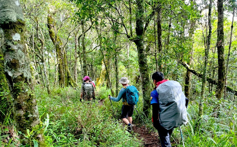
Shadow trail through tropical rain forest.
The Senaru trekking route is widely known as the “shadow trail” because it passes through dense tropical rainforests, offering a cooler and more shaded climb compared to the open savannah of the Sembalun route. It is the primary gateway for trekkers aiming to reach the Senaru Crater Rim (2,641m) for stunning views of the crater lake.
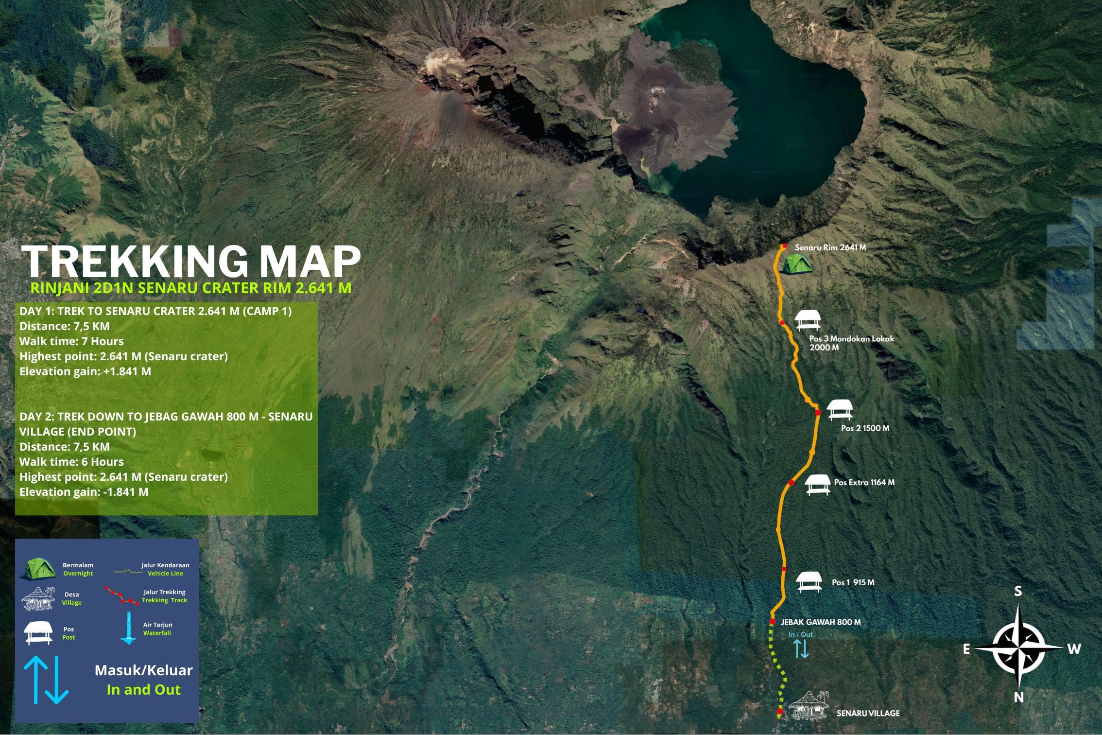
Senaru Trekking Route Overview.
- Starting Point. Senaru Village (~601m).
- Main Destination. Senaru Crater Rim (Plawangan Senaru) at 2,641m.
- Distance. Approximately 9–9.2 km one-way to the rim.
- Duration. Typically 6–7 hours of walking to reach the rim.
- Difficulty. Moderate to challenging. While shaded, the trail is a continuous climb with an elevation gain of over 2,000 meters.
Key Highlights of Senaru Trekking Route.
- Jungle Immersion. The lower sections are home to black monkeys (Lutung), macaques, and diverse tropical birds.
- The Crater Rim View. Offers one of the best panoramic views of Segara Anak Lake and the active Mount Barujari cone from above.
- Nearby Waterfalls. Senaru Village is the base for visiting two of Lombok’s most famous waterfalls, Sendang Gile and Tiu Kelep, often visited as a warm-up the day before a trek.
Popular Itineraries via Senaru Trekking Route.
- 2 Days / 1 Night (Crater Rim Only). Ascent to the rim for sunset/sunrise, then return to Senaru Village. Ideal for those not seeking the 3,726m summit.
- 3 Days / 2 Nights (Lake & Hot Springs). Descend from the rim into the crater to visit the lake and natural hot springs before returning via Senaru or exiting through the Torean valley.
- 4 Days / 3 Nights (The Full Loop). Often starts in Sembalun for the summit push and uses the Senaru route as a descent to enjoy the forest at the end.
What’s the difference between Senaru Trekking route and the Sembalun trail?
The main difference between the Senaru and Sembalun trails is their starting elevation and purpose: Sembalun is the most direct route to the summit, while Senaru is preferred for lush scenery and crater rim views.
Comparison at a Glance
| Feature |
Sembalun Trail (East) |
Senaru Trail (North) |
|---|---|---|
| Primary Goal | Reaching the 3,726m summit. | Crater Rim views and lake access. |
| Starting Altitude | ~1,150 meters (higher start). | ~601 meters (lower start). |
| Terrain | Open savannah grasslands. | Dense tropical rainforest. |
| Climate | Hot and exposed to direct sun. | Cool, shaded, and humid. |
| Initial Difficulty | Gentle climb on the first day. | Steep, continuous ascent from the start. |
| Best For | Faster acclimatization for the summit. | Beginners or those wanting a “greener” hike. |
Key Trail Characteristics
- Sembalun Route. Because you start higher, you have a “head start” on elevation, making it the most efficient path for a 2-day summit trek. However, the lack of shade means you are exposed to heat and wind all day.
- Senaru Route. This trail is often used as a descent route for longer treks (e.g., 3D2N Sembalun-Senaru) because the forest canopy provides a refreshing break from the sun. It offers the most iconic views of Segara Anak Lake directly from the Senaru Crater Rim.
- Torean Route. Often mentioned as a third option, it is a dramatic valley route known for waterfalls and rivers but is considered more technically demanding due to its terrain.
Which one is the best, Senaru trekking route or Sembalun?
Neither is “better” overall; the “best” one depends entirely on whether your priority is reaching the highest peak or enjoying lush scenery.
Choose the Senaru Trail if…
- You want the best Lake views. The panorama of Segara Anak from the Senaru Crater Rim is arguably the most iconic sight on the mountain.
- You prefer the jungle. Most of the hike is under a tropical forest canopy, keeping you cool and protected from the sun.
- Downside. You start much lower (601m), meaning you have to climb more total vertical meters just to reach the camp. It is a relentless, steep uphill from step one.
Choose the Sembalun Trail if…
- Your goal is the Summit. This is the most efficient route to 3,726m. Because you start at a higher elevation (1,150m), the climb to the first camp is technically easier on your lungs.
- You like wide-open views. You’ll hike through vast, golden savannah grasslands that look like a movie set.
- Downside. There is almost no shade. The sun will be intense, and the final “Bukit Penyesalan” (Regret Hill) is a steep, dusty slog.